Highland Scenic Highway shows West Virginia’s beauty
RICHWOOD – The Highland Scenic Highway is a Pocahontas County highway included in the National Forest Scenic Byway and is the highest major roadway in West Virginia.
It is 43 miles in length from Richwood to U.S. Route 219, 7 miles north of Marlinton. The two-lane highway follows State Route 39/55 for 21 miles, going from Richwood to the Cranberry Mountain Visitor Center. The road then turns onto State Route 150 for the 22 mile Parkway section.
The Scenic Highway, dedicated in 1980, travels along the Allegheny Highlands and Plateau. From Richwood, which has an elevation of 2,325 feet rises to over 4,500 feet along the Parkway. More than 60 percent of the highway is above 4,000 feet, thereby making it the highest major roadway in the state. The altitude also makes it one of the highest in the East.
The road is not maintained in the winter months however, but access is not prevented during the winter. Commercial traffic is not allowed and the speed limit is 45 miles per hour. Snow fall in the winter is generally close to 180 inches on Snowshoe Mountain, which has skiing, snowboarding, cross country skiing, snowshoeing, and other winter events. It’s not unusual to have May frost or November snow.
Fall’s peak colors typically occur the final week of September into the first week of October.
Among the attractions along the Highland Scenic Highway are many of West Virginia’s most popular. They are the Beartown State Park, Cass Scenic Railroad State Park, Cranberry Glades, Droop Mountain Battlefield, Durbin and Greenbrier Valley Railroad, The Falls of Hills Creek, Greenbank Radio Telescope, Greenbrier River Trail, Monongahela National Forest, Pearl S. Buck birthplace, Seneca State Forest, Snowshoe Mountain and Watoga State Park..
The highway also includes the World War II Mill Point Prison Camp, just east of Cranberry Glades. The camp housed federal prisoners including conscientious objectors and moonshiners.
Four scenic overlooks are found along the Parkway which provide scenic views of the Allegheny Highlands. The Honeycomb Rocks are located at 1.3 miles east of the Williams River Bridge.
The parkway section also provides scenic overlooks of Cranberry Glades and the Cranberry Wilderness to the west. And to the east, there are Ridge-and-valley Appalachians from points along the Allegheny Front. The overlook at Black Mountain gives an educational boardwalk which tells about the irresponsible timbering practices leading to a destructive forest fire that left the area barren for decades.
The parkway also provides access to recreational areas along the Cherry, Cranberry, and Williams Rivers, with trout n abundance. The West Virginia Division of Natural Resources stocks the streams with rainbow, brook, brown, and golden trout. Summit Lake, which is a 42-acre reservoir, has trout, bass, and panfish. Boats with electric trolling motors are allowed on the lake. Hunting is available in the Monongahela National Forest according to West Virginia state regulations.
Local News
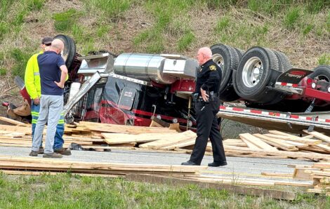
Fatal wreck still under investigation

Ohio Lt. Gov. Jim Tressel visits AOMC for WorkOhio tour
Ohio bill would create Gold Star Family driver’s license
MARIETTA – Soon family members who lost a loved one in military service will be able to make benefit claims by ...

U.S. Sen. Capito calls for unity among West Virginia Republicans following contentious primary
Wood County looking at changes in conducting elections
PARKERSBURG – Wood County officials are going to be looking at different ways of conducting elections in the ...
Justice Department calls for rejection of WV Secretary of State motion to dismiss voter registration case
CHARLESTON - The U.S. Department of Justice said in a legal filing Thursday that it has the right to access ...