The Way I See It: The Ohio River has evolved into a series of lakes
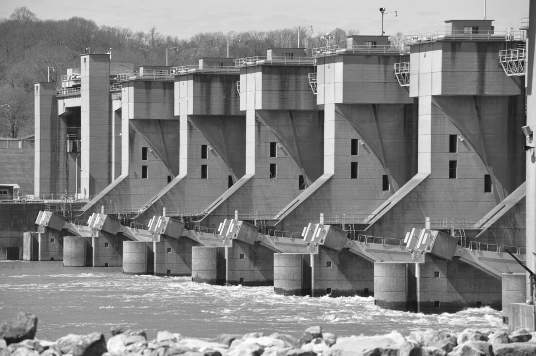
Water pours through the Belleville dam. The dam keeps the water level of the Ohio River at a consistent depth in the pool that includes Marietta and Parkersburg. (Photo by Art Smith)
Think about the Ohio River and you are likely to think about the wide body of water flowing gently past Marietta, Belpre and Parkersburg as giant barges move materials up and down the river and boaters dart about on the Ohio and up the numerous tributaries.
Adequate water in the Ohio River was not always a given for boat traffic trying to use the waterway. Low water was a frequent issue for early travelers.
For those first arriving here by boat in the 1700s the rivers were untamed and flowed naturally. During dry seasons this meant that boat traffic would frequently slow or even come to a halt. When the Lewis and Clark expedition traveled down the Ohio in 1805, the river was so low that at times, they had to get off the boat with shovels and dig a trench and then manually drag the boat downstream.
Low water would be problematic for Marietta’s ship building industry, which had to use “high water season” to move boats down the Gulf of Mexico.
Dams on the river would provide a solution. Small wing dams were constructed on the back side of islands, including those near Marietta and Parkersburg, to force more water down the main channels.
The first damming of the Ohio River was completed in 1929. Decades later both the Muskingum and the Little Kanawha had dam systems designed to give those rivers a consistent depth. The Ohio River projects produced 51 wicket dams, each with 600 by 110-foot lock chambers. Lock walls and old buildings can still be found at many of the locations up and down the river.
The Corps of Engineers began a massive modernization of the system in the 1950s that reduced the number of dams to 20, provided longer locks and raised the pool level behind each dam considerably.
In the Mid-Ohio Valley two of the dams impact our section of the river. Willow Island Dam, which contains the river in the Newport and St. Marys areas, and Belleville Dam, 42. 2 miles downstream from Willow Island. Marietta, Parkersburg and Belpre are all within the Belleville pool as are the lower sections of the tributaries that flow into it.
Construction of the locks and dams at Belleville began in 1962. In November 1968, the pool was raised to the level that we see today.
The higher water changed forever how we view the riverfronts. The river level in Marietta eliminated the need for a dam. Lock and dam No. 1 was removed by an explosion. The lock house remains today, as does the lock wall on the west side. It’s why the first dam on the river today, in Devola, is number 2. It’s also a good place to get an understanding on how much the river rose in Marietta.
Some old structures are now under water. The stones of the levee on Ohio Street extend well into the river. People fishing have noted the structures under water, including stairs near old locks.
Dams on the Ohio are meant to preserve a consistent water depth so commercial carriers can use the waterway year-round. The series of reservoirs created do not really control flooding because they can only be lowered so much and still provide a navigable waterway.
Many of the dams, including Willow Island and Belleville, have been retrofitted to generate hydroelectric power. Both dams are capable of producing more than 40 megawatts of power, enough to power thousands of homes by harnessing the power of the water as it drops from one pool level to the next one downstream.
It’s been nearly 60 years since the large Ohio River dams turned the once unpredictable Ohio River into a long series of managed lakes, allowing both recreation and commerce to move freely up and downstream.
Art Smith is online manager of The Marietta Times and The Parkersburg News. He can be reached at asmith@mariettatimes.com.
Local columns

Op-ed: The foundation of a century – it’s time for West Virginia’s second quarter

Reporter’s Notebook: Suiting up for the session
Look Back: A great train heist

Mid-Ohio Valley Climate Corner: Data centers taking pages from coal baron playbook

Cracking the Code: The rest of the story
