
3 twisters on ground in region at same time, National Weather Service says
Trending
PARKERSBURG – Three tornadoes that touched down in Washington County and crossed the Ohio River into West Virginia last week were likely on the ground at the same time, the National Weather Service said.
The Weather Service late Friday and Saturday nights issued preliminary assessments of the tornadoes from Washington County to Pleasants, Tyler, Ritchie and Doddridge counties on Tuesday afternoon.
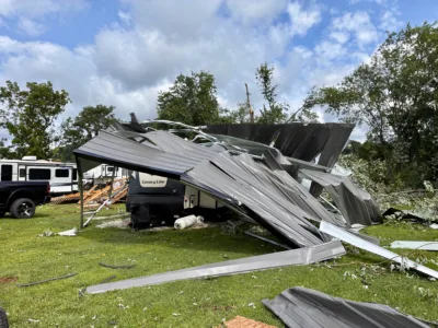
The tornadoes caused damage in the counties where they touched down, blowing roofs off structures, signs off stores and bridges, toppling antenna towers, overturning trailers, breaking tree limbs and felling trees across roads and power lines that caused thousands of power disruptions. Less than 100 customers remained without power as of Sunday morning in Pleasants County, where repairs were expected to be completed later in the day, according to the FirstEnergy outages report.
Multiple tornadoes simultaneously touching down is a rare occurrence for the region, Simone Lewis, a meteorologist for the Weather Service in Charleston, said on Sunday. The three on Tuesday were about 10 miles apart.
"It is fairly unusual," Lewis said.
Tornado No. 1 was rated EF2, a twister with wind speeds of 111 to 135 mph, and began around 4:15 p.m. between Hartline Road and Zimmer Road in the Caywood community of Washington County, then traveled southeast through the Hills community, knocking over a silo and damaging several homes.
The most severe damage and where the EF2 rating was reached was along Ohio 26 near Township Road 635, the service said. An area of pine trees about 600 yards long and 400 yards wide "was completely mowed down with every trunk snapped several feet above the ground," the service said.
The weakened tornado, still causing sporadic tree damage, continued southeast and crossed the Ohio River on the west side at Newells Run and entered West Virginia at Belmont where it damaged camper trailers at Riverview Estates. West Virginia Gov. Patrick Morrisey, who toured damages in Pleasants County on Saturday morning, discussed relief plans at a press conference at Riverview Estates.
The tornado continued east, causing sporadic damage in the Green Run community before dissipating around 4:30 p.m., just before it would have merged with Tornado No. 2, the service said.
Tornado No. 2 began around 4:25 p.m. between Newells Run and Kerr Run roads in Washington County, the Weather Service said. Numerous trees were uprooted or snapped by the tornado that continued southeast through Newport, where minor damage was done to homes and trees, the service said.
The tornado strengthened as it crossed the Ohio River into West Virginia at the Hi Carpenter Bridge at St. Marys. A large sign was nearly blown off the bridge where a patch of trees sustained significant damage, causing traffic delays on West Virginia 2 at the bridge on Wednesday while repairs were being made.
No. 2 then went southeast up the hillside where it reached peak intensity and a high end EF2 rating near Greens Run Road and West Virginia 16, causing significant damage to several homes, leveled a 600-by-300-yard patch of hardwood trees and buckled a large communications tower, the Weather Service said. The path of the tornado then became intermittent as it skipped along Route 16 to the Cloverdale community and ended just before the Ritchie County line near Seckman Ridge Road, dissipating around 4:45 p.m., the service said.
Tornado No. 3 touched down at 4:31 p.m. in the Wayne National Forest in Washington County near Archers Fork Road, traveled southeast through the Leith Community and crossed the Ohio River into West Virginia near Raven Rock, the Weather Service said. Following a non-continuous path toward the southeast, sporadic tree damage occurred in northern Pleasants County, southern Tyler County and northern Ritchie County before lifting at 4:59 p.m. near Arnolds Creek Road in Doddridge County.
"The tornado track between Raven Rock and damage found near the Tyler/Ritchie county line is uncertain and should be considered preliminary due to no damage points currently identified in that stretch," the Weather Service said. "We assume that due to a strong and persistent circulation noted on radar that more damage occurred in this section of the path. However, later surveys may reveal otherwise."
The Weather Service has documented five tornadoes in Pleasants County. The last tornado was on July 27, 2014, and rated EF1.
Three have been documented in Ritchie County, the last an EF1 also on July 27, 2014.
Three tornadoes have been documented in Tyler County. The last, rated EF1, was on May 23, 2000.
In Doddridge County, four tornadoes have been documented, the last occurring on Oct. 4, 1986. That was rated EF1.
Sixteen tornadoes have been documented in Washington County by the Weather Service. The last was rated EF0 on July 29, 2021.
The intensity of Tuesday's tornado also was unusual in Washington County, according to Lewis. Three of the tornadoes in Washington County have been rated EF2, occurring in 1907, 1971 and 1981, Lewis said.
"It's been a while," she said.
Jess Mancini can be reached at jmancini@newsandsentinel.com.