Building Blocks: Locks and dams on Muskingum have made river navigable since 1841
A glance at the buildings and locations that have shaped the Mid-Ohio Valley
-
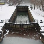
- Photo by Art Smith The lock chamber of the lock No. three in Lowell.
-

- Photo by Art Smith Birds search for food in the rough waters below the Lowell dam.
-

- Photo by Art Smith The railing around the stone wall of the southern end of the Lowell Lock.
-

- Photo by Art Smith A Great Blue Heron walks in the shallow water of the Muskingum River below the dam in Lowell.
-

- Photo by Art Smith Ice clings to a tree that is stuck on the top of the Lowell Dam.
-

- Photo by Art Smith Steps lead from the canal on the upstream end of the Lowell Lock.
-

- Photo by Art Smith Part of the hand operated mechanism of the lock.
-

- The double lock and the dam in Marietta was removed in the 1960s after the Ohio River was raised by the construction of the large lock and dam in Belleville.

Photo by Art Smith The lock chamber of the lock No. three in Lowell.
When Pioneers first arrived in Marietta in 1788 they landed and settled near the mouth of the Muskingum River.
The river had been an important trading route for the Indians and it would become an important waterway for the new settlers as they worked to tame a wild state.
In 1837 work began on a lock and dam system that would turn the river into a series of 11 pools and allow boats to travel the length of the river that starts above Zanesville at Coshocton where the Walhonding and Tuscarawas rivers meet. The upper most dam was constructed in Dresden, the southern most a few hundred yards from the mouth of the river in Marietta.
The locks and dams system took years to complete and were costly for the young state. By the time it opened in 1841 the construction had cost $1,626,028 and was the most expensive public works project the state had ever attempted.
Designed by West Point graduate Maj. Samuel Curtis, the system of 10 dams and 11 locks connected the Muskingum River to the Ohio and to the Erie Canal at Dresden and provided a navigable waterway from Marietta to Lake Erie.

Photo by Art Smith Birds search for food in the rough waters below the Lowell dam.
Today the locks operated much as they did 157 years ago, by hand. During the boating season workers manually open valves to let water fill or empty the 160-foot-long chambers. The locks can hold several pleasure boats at once, or one Valley Gem-size sternwheeler, a boat that fits into the chamber like a hand into a glove.
Construction of the locks opened Southeastern Ohio to trade. In a time before air travel or decent roads, the rivers were the main highways.
Built to withstand most flooding, the dams and locks were damaged by the 1913 flood that caused widespread damage up and down the Muskingum. All bridges along the river were destroyed and the lock system and dam system were damaged. The canals connecting the Muskingum were destroyed by the massive flooding. By the time the locks and dams were repaired five years later, Ohioans had found other ways to move goods across Ohio.
By 1948 commercial use of the river had fallen to such a low level that the U.S. Army Corps of Engineers closed the locks. In 1958 the river system was returned to the state. Today it operates as the Muskingum River State Park and is a National Historic Civil Engineering Landmark.
The locks are operated June through Oct. 14, making the river navigable from Marietta as far as lock 11, which is closed until further notice.

Photo by Art Smith The railing around the stone wall of the southern end of the Lowell Lock.
Lock and dam No. one, which was in Marietta between the Putnam Bridge and the Historical Harmar Bridge was removed following the construction of the Belleville Dam on the Ohio. That dam raised the Ohio and eliminated the need for the dam.
Marietta had a unique double wide lock that replaced an earlier one that was on the west side of the river and proved to be too small. Some of the lock walls for both locks exist today.
Muskingum locks and dams that remain in Washington County include the ones in Devola, Lowell, Beverly and Luke Chute.
***
By the Numbers

Photo by Art Smith A Great Blue Heron walks in the shallow water of the Muskingum River below the dam in Lowell.
* Year built: The locks and dams were constructed between 1836 and 1841.
* How many: 11 were built from Marietta to Ellis.
* How many remain: 10 remain. Lock and dam number one was in Marietta and was removed in the 1960s after the level of the Ohio was raised by the construction of the Belleville Lock and Dam.
* Size of a Muskingum River lock: Locks are approximately 35 feet wide and 160 feet long, which is long enough for the Valley Gem to pass through.
* Length of system: It was built to raise boats 100 feet over the 90 miles of river between Marietta and Dresden.

Photo by Art Smith Ice clings to a tree that is stuck on the top of the Lowell Dam.
* Reason for construction: Linking the Ohio canal system to the Ohio River.
* Reason for decline: The canal system went into decline following flooding and the increased use of railroads. The decline started around 1880.
* Use today: Pleasure boats.

Photo by Art Smith Steps lead from the canal on the upstream end of the Lowell Lock.
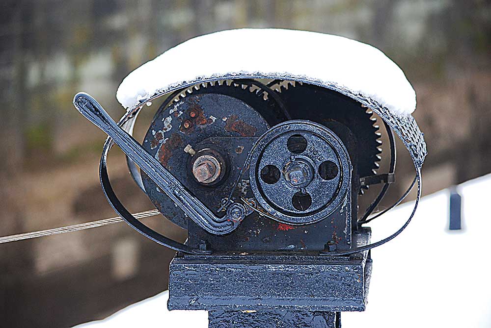
Photo by Art Smith Part of the hand operated mechanism of the lock.

The double lock and the dam in Marietta was removed in the 1960s after the Ohio River was raised by the construction of the large lock and dam in Belleville.
Local News

Hallmark holiday movie fans are flocking to Connecticut’s quaint filming locations

In Alaska’s warming Arctic, photos show an Indigenous elder passing down hunting traditions

‘Zootopia 2’ reclaims No. 1 spot at box office, grosses $1B worldwide

Grad Tidings: West Virginia University at Parkersburg conducts fall commencement

Marietta Police Department proves eager elves with annual Shop With a Cop program