Grave Concerns: Survey aims to identify, map burial sites in Marietta’s Mound Cemetery
-
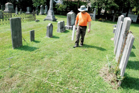
- Jarred Burks, director of archaeological geophysics for Ohio Valley Archaeology Inc., walks along a designated area of Mound Cemetery Monday. The company has been contracted by the City of Marietta to perform multiple scans to help identify where burials took place over the 220-plus-year history of the cemetery. (Photo by Evan Bevins)
-

- Alex Flores, geophysical survey assistant with Ohio Valley Archaeology, places a rope to mark the area where a co-worker will walk and scan with a magnetometer Monday at Mound Cemetery. The company has been contracted by the City of Marietta to perform multiple scans to help identify where burials took place over the 220-plus-year history of the cemetery. (Photo by Evan Bevins)
-
- Washington County Historical Society member Mike Ryan applied sidewalk chalk to this marker in Mound Cemetery in an effort to identify who was buried in the grave. He photographs the markers and uploads the images to a computer, where he can adjust the contrast to help him better read what was carved on them. (Photo by Evan Bevins)
-
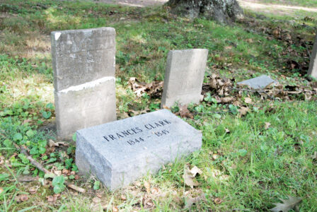
- The Washington County Historical Society is placing new monuments on Mound Cemetery grave markers that have deteriorated to the point they are no longer legible. (Photo by Evan Bevins)
-
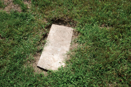
- Washington County Historical Society member Mike Ryan is researching Mound Cemetery grave markers like this one that have deteriorated or do not have enough information to indicate who was buried at the site. (Photo by Evan Bevins)
-

- Jarred Burks, director of archaeological geophysics for Ohio Valley Archaeology Inc., walks along a designated area of Mound Cemetery Monday. The company has been contracted by the City of Marietta to perform multiple scans to help identify where burials took place over the 220-plus-year history of the cemetery. (Photo by Evan Bevins)

Jarred Burks, director of archaeological geophysics for Ohio Valley Archaeology Inc., walks along a designated area of Mound Cemetery Monday. The company has been contracted by the City of Marietta to perform multiple scans to help identify where burials took place over the 220-plus-year history of the cemetery. (Photo by Evan Bevins)
MARIETTA — Surveys of Mound Cemetery are underway using technology that paints a picture of what’s below the surface without turning any dirt.
“That machine measures the Earth’s magnetic field,” said Jarrod Burks, director of archaeological geophysics for Ohio Valley Archaeology Inc., in between passes over the ground with a handheld magnetometer. “Things underground will affect the Earth’s magnetic field.”
For example, reinforced concrete vaults are quite magnetic, he said, while graves from the 1800s would be more subtle. But even the soil burned in a fire by native inhabitants 2,000 years ago can be detected, as can steel wires inside plastic flowers left at graves.
The magnetometer survey will be followed by ground-penetrating radar and an electromagnetic induction meter under a $49,327 contract funded by American Rescue Plan Act money allocated to the City of Marietta.
“They each detect a slightly different kind of property in the ground,” Burks said.
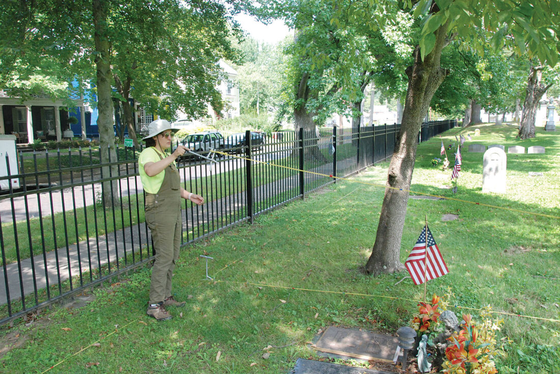
Alex Flores, geophysical survey assistant with Ohio Valley Archaeology, places a rope to mark the area where a co-worker will walk and scan with a magnetometer Monday at Mound Cemetery. The company has been contracted by the City of Marietta to perform multiple scans to help identify where burials took place over the 220-plus-year history of the cemetery. (Photo by Evan Bevins)
It’s part of an effort in conjunction with the Washington County Historical Society to map where people were interred and identify as many as possible.
“It’s literally going to show us where all the bodies are buried,” said Mike Ryan, a member of the Historical Society.
Three years ago, society members embarked on an effort to address tombstones that had deteriorated to the point where those buried in the graves they marked could no longer be identified, he said. City officials OK’ed it but also expressed interest in developing a map of who was buried where.
Twenty-six graves got new markers last year, and there’s a list of about 50 markers that still cannot be read. Ryan continues to research those and uses methods like applying sidewalk chalk to the damaged markers, then uploading photos of them to a computer to adjust the contrast so he can better read what fragments remain.
“You can’t really do a rubbing on these old tombstones. They’re too coarse,” he said.

Washington County Historical Society member Mike Ryan applied sidewalk chalk to this marker in Mound Cemetery in an effort to identify who was buried in the grave. He photographs the markers and uploads the images to a computer, where he can adjust the contrast to help him better read what was carved on them. (Photo by Evan Bevins)
Ryan’s research has also produced a list of approximately 400 people said to have been buried at Mound Cemetery but for whom no markers have been found.
Then there’s the area in one part of the cemetery attributed in records only to a Washington County sheriff in the 1860s. No names have been found to suggest who is buried there, but Ryan theorizes it could have been used for indigent people who could not afford their own plot. It’s hoped that the Ohio Valley Archaeological surveys will provide an idea of how many people were interred there.
“You know when you’ve detected one (a grave),” Burks said. “You don’t always know when you haven’t.”
The ground-penetrating radar is similar to a sonogram, producing readings every inch or so in the ground, he said. The first things they see are usually tree root patterns but as it goes deeper, information about what else might be down there often emerges.
The electromagnetic induction meter creates its own magnetic field and detects responses in the ground, providing different data than the other methods. Burks estimated it will take about a week for each method to cover the entire 3.5-acre cemetery, not including the Conus mound in the center.

The Washington County Historical Society is placing new monuments on Mound Cemetery grave markers that have deteriorated to the point they are no longer legible. (Photo by Evan Bevins)
They started Monday, with Burks walking with the magnetometer in a straight line in an effort to cover every bit of the ground. They can’t assume everyone was buried in an orderly row, because that wasn’t done in the early years, Ryan said. The first recorded burial was in 1801.
“There probably are a lot of strange grave locations,” Burks said.
Eventually, there could be additional burials in the cemetery, Marietta Mayor Josh Schlicher said.
“A lot of our citizens would like to have space in Mound Cemetery,” he said. “We have a lot of space there that we’re not exactly sure if it’s available or not available.”
Increased interest in cremation also means not as much space would be required, Schlicher said. The city plans to add above-ground cremation columbariums at both the Mound and Oak Grove cemeteries. The mayor described them as scaled-down versions of mausoleums whose exteriors would match the aesthetics of the cemeteries.

Washington County Historical Society member Mike Ryan is researching Mound Cemetery grave markers like this one that have deteriorated or do not have enough information to indicate who was buried at the site. (Photo by Evan Bevins)
There could very well be additional space available, Ryan said.
“There’s a lot more room in here than people realize,” he said. “There’s probably room for 5,000 (graves). And my lists go just over 4,000.”
Evan Bevins can be reached at ebevins@newsandsentinel.com.
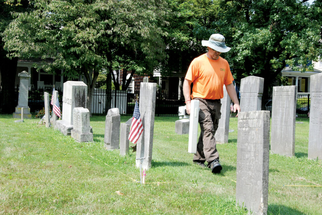
Jarred Burks, director of archaeological geophysics for Ohio Valley Archaeology Inc., walks along a designated area of Mound Cemetery Monday. The company has been contracted by the City of Marietta to perform multiple scans to help identify where burials took place over the 220-plus-year history of the cemetery. (Photo by Evan Bevins)
Local News
Voting continues in Washington County, procedural error on library levy

Dick Cheney, one of the most powerful and polarizing vice presidents in US history, dies at 84

Mid-Ohio Valley Health Department reports rise in whooping cough
WesBanco exhibit looks to increase interest in artist Christine Rhodes

SNAP struggles to impact 36K West Virginians